


Category: Vendor Videos
QuestUAV Parachute Landing
0 Views0 Comments0 Likes

Geodesign Summit 2015: Attendee Feedback
0 Views0 Comments0 Likes
The Geodesign Summit 2015 featured a variety of speakers and topics focused on designing a better and smarter built environment. This video produced by GeoSpatial Stream presents immediate feedback from attendees describing what geodesign means to them and how they plan to apply what they learned at the event to their jobs and lives.

SpaceCurve Introduces Spatial at the Speed of Reality
0 Views0 Comments0 Likes
GeoSpatial Stream's Todd Danielson conducted an Internet Interview with SpaceCurve's CEO Dane Coyer and Founder Andrew Rogers. They spoke about the company's inception, Big Data, spatial indexing and business applications as well as how SpaceCurve created new technologies to integrate these varied components.

Simulating Spaces for Social Distancing
0 Views0 Comments0 Likes
Todd Danielson, Informed Infrastructure's editorial director, interviewed Eduardo Lazzarotto, Bentley Systems’ director of Product Management for Facilities Engineering, via webcam.

OcuTech 360 Video Mapping
0 Views0 Comments0 Likes
OcuTech 360 is an inclusive provider of 360 degree visual technologies that are applied in geospatial mapping. Thanks to state of the art hardware and software, you can now digitize infrastructure and interact with data in 3D space, take 3D measurements, and annotate. For more info, please visit ocutech360.com or contact [email protected].

Smart Mapping from Esri
0 Views0 Comments0 Likes
Smart Mapping is an exciting new capability in ArcGIS Online that will change how you make maps.
senseFly Mini Drones
0 Views0 Comments0 Likes
Imagine being able to see the world from a totally new point of view.

Esri’s Geotrigger Service Explained
0 Views1 Comments0 Likes
Matt Ball spoke with Amber Case, director of Esri's R&D Center in Portland, at the Local Data Summit in Denver on Feb. 25, 2014. The conversation ranges from accessible geospatial technology, the ubiquity of mobile devices, and the connections that are made with location awareness and location-based alerts.
Autodesk VTN Consulting
0 Views0 Comments0 Likes
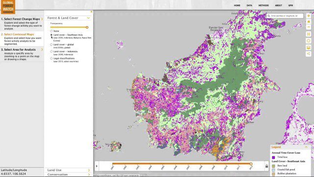
Global Forest Watch Commodities—Geospatial Tools to Help Reduce Greenhouse Gas Emissions from Land-Use Change
0 Views0 Comments0 Likes
This app provides three tools for businesses interested in good forest management: Suitability Mapper, which enables businesses to identify degraded areas best suited for commodity development as an alternative to clearing new forest areas; Forest Analyzer, which provides information on land cover and land use to monitor and evaluate change to forests on commodity concessions; and Roundtable on Sustainable Palm Oil (RSPO) Support tool, which users can complete for an analysis of forest change on certified areas and use the analysis for the compensation procedure required by RSPO while also enabling commodity buyers to make informed sourcing decisions.


