
Browse Archives
GEOINT Keynote: James Clapper, Director of National Intelligence (Part 4/Q&A)
0 Views0 Comments0 Likes
Part 4 of the GEOINT Symposium keynote address from James Clapper, Director of National Intelligence, completing the Q&A session.
GEOINT Keynote: James R. Clapper, Director of National Intelligence
0 Views0 Comments0 Likes
The U.S. Geospatial Intelligence Foundation (USGIF) recorded the keynote speech of James Clapper, director of National Intelligence, at the 2016 GEOINT Symposium on May 16, 2016, in Orlando, Fla.
GEOINT Keynote: Marcel Lettre, Under Secretary of Defense for Intelligence
0 Views0 Comments0 Likes
The U.S. Geospatial Intelligence Foundation (USGIF) recorded the keynote speech of Marcel Lettre, Under Secretary of Defense for Intelligence, at the 2016 GEOINT Symposium on May 16, 2016, in Orlando, Fla.
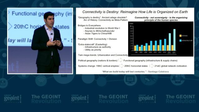
GEOINT Keynote: Parag Khanna, Author on Mapping
0 Views0 Comments0 Likes
The U.S. Geospatial Intelligence Foundation (USGIF) recorded the keynote speech of Parag Khanna, author, “Connectography: Mapping the Future of Global Civilization," at the 2016 GEOINT Symposium on May 16, 2016, in Orlando, Fla.
GEOINT Keynote: Robert Cardillo, Director, NGA
0 Views0 Comments0 Likes
The U.S. Geospatial Intelligence Foundation (USGIF) recorded the keynote speech of Robert Cardillo, Director of the National Geospatial-Intelligence Agency (NGA), at the 2016 GEOINT Symposium on May 16, 2016, in Orlando, Fla.
GEOINT Keynote: Stephen P. Welby, Assistant Secretary of Defense for Research and Engineering
0 Views0 Comments0 Likes
The U.S. Geospatial Intelligence Foundation (USGIF) recorded the keynote speech of Stephen P. Welby, Assistant Secretary of Defense for Research and Engineering, at the 2016 GEOINT Symposium on May 16, 2016, in Orlando, Fla.
Geospatial as an Integral Part of Information Management
0 Views0 Comments0 Likes
The V1 Video team interviewed Fred C. Collins, Ph.D., Distinguished Engineer and Bluemix Evangelist at IBM, at the ENVI Analytics Symposium in Boulder, Colo. Bluemix is the company’s platform-as-a-service that supports geospatial as a key component of the architecture. We spoke about the growing awareness and reliance on geospatial capabilities for data management and analysis, and the flexibility of the Bluemix cloud-based tools that can be extended with hundreds of services.
GeoSpatial Stream 11_18 (protected areas, geolocated tweets, infrastructure investment and more)
0 Views0 Comments0 Likes
This Daily Digest was published on 11/18/2013. Topics covered include identifying protected habitat areas, satellite imagery legislation, geolocated Tweets to reveal travel patterns, Indonesian infrastructure investment, and more.

GeoSpatial Stream Broadcast from London
0 Views0 Comments0 Likes
Reporting from London, Todd Danielson covers the important announcements from the Bentley Year In Infrastructure Conference, the Bentley 500 list of top infrastructure owners worldwide, Bentley's acquisition of MOSES Software, a new columnist for Sensors & Systems, and more.
GEOSS Functions and Main Components
0 Views0 Comments0 Likes
Infrastructure and Data: The Global Earth Observation System of Systems (GEOSS) functions and main components, sustainability, user access and benefits.


