
Browse Archives
Airbus Defence and Space Launches WorldDEM DTM
0 Views0 Comments0 Likes
Airbus Defence and Space released its global elevation model that was captured by the twin TerraSAR-X and TanDEM-X radar satellites in 2014 and now is producing Digital Terrain Models based on this dataset. The 12-meter-resolution pole-to-pole elevation data are a major improvement upon the commonly used 30-meter USGS SRTM data. Earth Imaging Journal spoke with Gertrud Riegler, WorldDEM Product Manager, Airbus Defence and Space, at the International Space Symposium about this new dataset and its many uses.
Airbus Defense and Space Dealing with Big Data Management and Delivery Issues
0 Views0 Comments0 Likes
The V1 Video team interviewed Jessi Dick, Senior Marketing Manager of Online and Software Partnerships at Airbus Defence and Space, at the 2015 Esri User Conference in San Diego. We spoke about the growing volumes of data and the company’s tools managing data via portals, systems, streaming services and custom solutions.
Alistair Stuart, Leica Geosystems, Interview
0 Views0 Comments0 Likes
Matt Ball interviews Alistair Stuart, sales of Airborne Sensors, Leica Geosystems. They discuss Leica's recent purchase of Aibotix and its Aibot X6 hexacopter. Stuart discusses the advantages of the UAS compared to other imagery vehicles in terms of cost, safety and portability.
Analytics, Ease of Use and Accessibility at Esri
0 Views0 Comments0 Likes
The V1 Video team interviewed Brian Lehman, director of Defense Business Development at Esri, at the GEOINT Symposium in Washington, D.C. We spoke about task-driven workflows that streamline multi-step processes, incorporating automation to ease the tedious nature of some lengthy geospatial processing and analysis functions. The company has developed a number of analytic tools that also ease integration, harnessing the power of geography to integrate intelligence data.
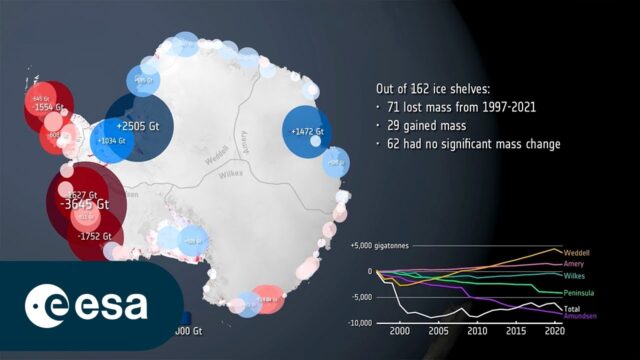
Antarctic Ice Shelf Demise
0 Views0 Comments0 Likes
New research, based largely on information from the Copernicus Sentinel-1 and ESA’s CryoSat satellite missions, has revealed alarming findings about the state of Antarctica's ice shelves: 40% of these floating shelves...

App Aids Satellite Imaging Awareness
0 Views0 Comments0 Likes
The V1 Video team interviewed Alex Herz, president of Orbit Logic, at the GEOINT Symposium in Washington, D.C. We talked about the company’s satellite imagery planning and scheduling capabilities as well as its new foray into apps to make satellite imagery more accessible to everyone. The SpyMeSat mobile application lets smartphone users know when imaging satellites are overhead, what their capabilities are, and has recently added tasking so users can order images directly from their phones.

APS Introduction for Trimble
0 Views0 Comments0 Likes
We created the introductory segment for Trimble's Public Safety division commercial.

Arcadis CEO Discusses Company Growth and Client Diversity
0 Views0 Comments0 Likes
The V1 Video team spoke with John Jastrem, CEO, Arcadis, at the company's office near Denver. The conversation covered Arcadis' growth strategy, how it invests in people, client diversity and what it takes to be a "thought leader."
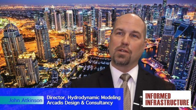
Arcadis Engineers Tackle Rising Seas and Drainage Systems
0 Views0 Comments0 Likes
The V1 Video team spoke with John Atkinson, Director, Hydrodynamic Modeling, Arcadis, at the company's office near Denver. The conversation covered Arcadis' Dutch heritage, engineering for rising sea levels, stormwater drainage, new models and data, and the company's commitment to open-source technology.
Arctic Death Spiral and the Methane Time Bomb
0 Views0 Comments0 Likes


