


Category: Daily Digests
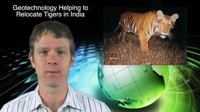
11_26 Asia-Pacific Broadcast (Gaofen-23, Hokkaido Map and More)
3.64K Views0 Comments0 Likes
This Asia-Pacific-focused GeoSpatial Stream broadcast discusses the recently launched Chinese Gaofen-23 remote-sensing satellite; researchers in India finding and relocating tigers; a new map of disputed territories off the coast of Hokkaido; Brisbane GIS Day, the largest GIS Day event in the world; the Locate 15 Conference; an Esri Australia contract with the Australian Department of Defence; a video about UN's FAO using geospatial technology; and more.
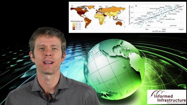
GeoSpatial Stream 11_18 (protected areas, geolocated tweets, infrastructure investment and more)
3.61K Views0 Comments0 Likes
This Daily Digest was published on 11/18/2013. Topics covered include identifying protected habitat areas, satellite imagery legislation, geolocated Tweets to reveal travel patterns, Indonesian infrastructure investment, and more.
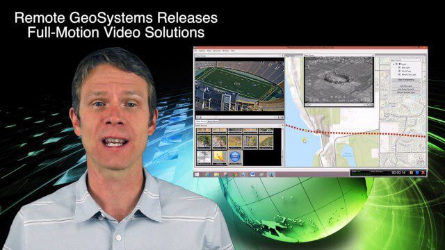
6_25 Infrastructure Broadcast (London’s Crossrail, DOT Grants and More)
3.61K Views0 Comments0 Likes
This infrastructure-themed GeoSpatial Stream broadcast discusses London's massive Crossrail project, Bentley's involvement in its BIM practices, and the completion of its tunnel boring; U.S. DOT grants to reduce traffic congestion; Canada's massive New Champlain Bridge project; an interview with HOK's Patrick MacLeamy; industry news from Remote GeoSystems, Esri, IMAGINiT Technologies, Pix4D, Innovyze, Flightline Geographics and Tablerock Land Survey; thoughts on Crossrail and the world's longest tunnel; and more.
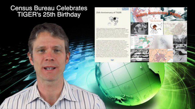
12_4 TIGER Broadcast (Database Milestones, People to Pixels and More)
3.57K Views0 Comments0 Likes
This GeoSpatial Stream broadcast discusses "People to Pixels" remote-sensing techniques that won a major award; the 25th anniversary of the U.S. Census Bureau's TIGER database; industry news from Esri, SmarterBetterCities, TomTom, Fleetlogic and ThinkGeo; clips from an interview with Greg Bentley, CEO of Bentley Systems; information about an upcoming Webcast on Structural Steel Fabrication; and more.
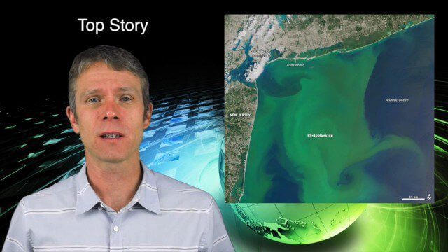
8_13 Earth Imaging Broadcast (Toxic Phytoplankton, Climate Change and More)
3.56K Views0 Comments0 Likes
This GeoSpatial Stream broadcast discusses the massive phytoplankton blooms along both U.S. coasts and the damage they are doing; NOAA reporting record high temperatures across the globe; NASA's CubeSat Launch Initiative; industry news from Bluesky Esri, ESA, Airbus and Harris Corp.; thoughts on toxic phytoplankton and climate change; and more.
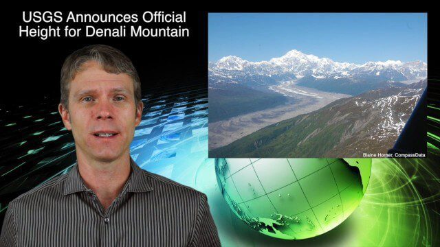
9_3 Environment Broadcast (Ocean Monitoring, Habitat Protection, Denali and More)
3.56K Views0 Comments0 Likes
This GeoSpatial Stream broadcast discusses ocean monitoring by the European Commission's NeXOS project; ocean-habitat monitoring off of Costa Rica, with the help of DigitalGlobe satellite imagery; a new official height for Denali Mountain; industry news from Trimble, Spatial Dimension, TerraGo, Esri, FlightAware and SimActive; a video from the EPA; and more.
1_15 Infrastructure Broadcast (Geodesign Summit, Road Maintenance and More)
3.54K Views0 Comments0 Likes
This Infrastructure-themed GeoSpatial Stream broadcast discusses the impending road-maintenance crisis worldwide as well as possible new spending initiatives; U.S. DOT grants to strengthen commercial vehicle safety via intelligent transportation systems; a new "drive by" heat-mapping system; industry news from USGIF, Esri, Innovyze and FARO; a video from the 2014 Geodesign Summit in anticipation of this year's event; and more.

4_14 Infrastructure Broadcast (Transportation Asset Management, Water Infrastructure Needs, and More)
3.51K Views0 Comments0 Likes
This infrastructure-focused GeoSpatial Stream broadcast discusses Transportation Asset Management; a report on water infrastructure; designs to protect against hurricanes; public-transit ridership; historical map archives; private infrastructure funding; news from Bluesky and Bentley Systems; rainwater-capturing infrastructure in Rotterdam, The Netherlands; and more.
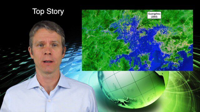
8_27 Asia-Pacific Broadcast (Rising Seas, Pollution, Drones and More)
3.49K Views0 Comments0 Likes
This Asia-Pacific-themed GeoSpatial Stream broadcast discusses rising sea levels in coastal cities; decreased air pollution in the Middle East; Australian researchers using drones to track wildlife; images of Typhoon Goni over Japan; industry news from Esri, Abu Dhabi, Korea Aerospace Research and Maptek; thoughts on urban population explosions in China and personal travel experiences; and more.
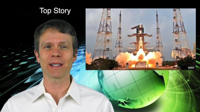
1_21 Asia Pacific Broadcast (GPS Alternatives, Nepal Landslides and More)
3.46K Views0 Comments0 Likes
This Asia-Pacific-themed GeoSpatial Stream broadcast discusses new alternatives to GPS, including the latest satellite launch for India's budding navigation system; an Australian tool for modeling wind dispersal; Indonesia mapping damaged peatlands; industry news from geoshepherds, Ordnance Survey and Esri Indonesia; a study indicating that landslides were less prevalent than expected after the 2015 Nepal earthquake; and more.


