


Category: Daily Digests

7_16 Asia Pacific Broadcast (New Satellites, Drones Catching Tax Cheats and More)
0 Views0 Comments0 Likes
This Asia Pacific-themed GeoSpatial Stream broadcast discusses new Asian geospatial satellites from India, China and Japan; V1 Media's upcoming Webcast on Earthquake safety; laser scanning to map and preserve Japanese castles and Malaysian caves; drones used in Indonesia to catch tax cheats; industry news from MDA and Google; thoughts on digital preservation; and more.

7_23 Esri UC Broadcast (Video Recap, Exhibitor News and More)
0 Views0 Comments0 Likes
This GeoSpatial Stream broadcast covers news and events from the recent Esri User Conference in San Diego, including a video recap of speakers and topics; news from Esri on the Special Achievement in GIS Awards, its Tapestry Segmentation system and a partnership with European Schoolnet; exhibitor news from Topcon Positioning Group, Airbus Defense and Space, LizardTech and Scene Sharp; a clip from an interview with Jack Dangermond, Esri's president and founder; and more.

7_23 Infrastructure Broadcast (AEC Market Reports, Smart Cities and More)
0 Views0 Comments0 Likes
This Infrastructure-themed GeoSpatial Stream broadcast discusses an optimistic AEC market report; a $16 billion commitment from the state of Washington for transportation improvements; a new LADOT public Web map for smart communities; laser scanning in Mexico; industry news from SmarterBetterCities, Topcon Positioning Group and PaveXpress; thoughts on seeing Informed Infrastructure in action in Chicago; and more.

7_30 Asia-Pacific Broadcast (Deforestation, Beijing Smog and More)
0 Views0 Comments0 Likes
This Asia-Pacific-focused GeoSpatial Stream broadcast discusses deforestation in Indonesia; IBM joining Beijing's fight against smog; Asian effects on mobile-device charging; Pakistan's move toward space technology; satellite imagery use in Australian vineyards; industry news from Spatial Dimensions, ScanEx, Maptek and Esri; geospatial insight into Indonesian politics; and more.
7_30 Spatial Broadcast (Esri UC Highlights, NASA News and More)
0 Views0 Comments0 Likes
This GeoSpatial Stream broadcast discusses highlights from the Esri User Conference; NASA news from the Kepler mission and a near-Earth-sized planet as well as satellite data noting plankton's effects on clouds and climate; industry news from SAP, Esri, Nepal and LizardTech; thoughts on the Kepler mission and the possibilities of life beyond Earth; and more.
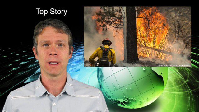
7_9 Earth Imaging Broadcast (California Fires, Drone Mayhem and More)
0 Views0 Comments0 Likes
This Earth Imaging-themed GeoSpatial Stream broadcast discusses the California Lake Fire and its mapping by satellites as well as amateur drone use that disrupted firefighting; NASA's work to develop drones with sense-and-avoid systems; satellite sensors using gravity to detect depleting groundwater basins; electromagnetic survey data for geology; industry news from Orbit Logic, 4D Mapper and Lockheed Martin; thoughts on amateur drone use; and more.
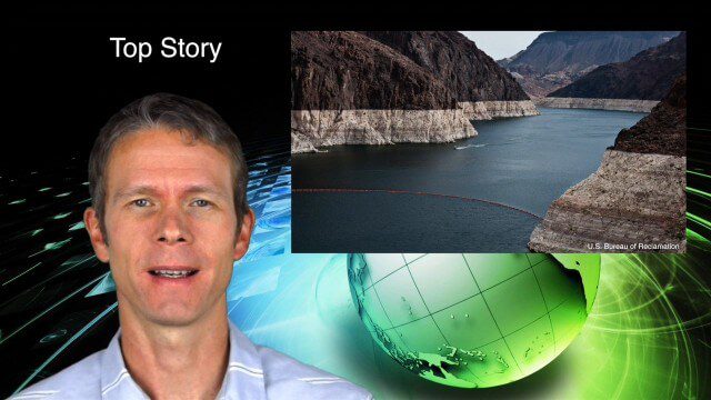
8_11 Water Resources Broadcast (Massive Groundwater Loss, Algal Blooms and More)
0 Views0 Comments0 Likes
This GeoSpatial Stream broadcast discusses a NASA study on massive groundwater loss in the Colorado River Basin; remote sensing to study algal blooms in Lake Erie; the USGS National Map Corps' latest addition; an Esri Story Map on the Football Hall of Fame; industry news from Pelydryn, Airborne Hydrography, Leica Geosystems, Geographic Technologies Group, URISA and Lockheed Martin; river pollution; and more.
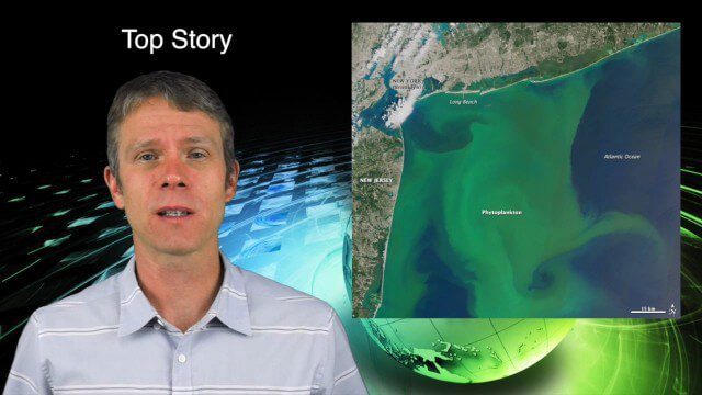
8_13 Earth Imaging Broadcast (Toxic Phytoplankton, Climate Change and More)
0 Views0 Comments0 Likes
This GeoSpatial Stream broadcast discusses the massive phytoplankton blooms along both U.S. coasts and the damage they are doing; NOAA reporting record high temperatures across the globe; NASA's CubeSat Launch Initiative; industry news from Bluesky Esri, ESA, Airbus and Harris Corp.; thoughts on toxic phytoplankton and climate change; and more.
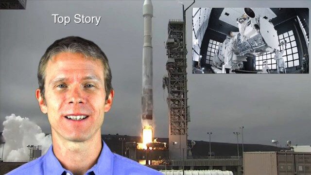
8_14 Remote-Sensing Broadcast (WorldView-3 Launch, NASA Satellites and More)
0 Views0 Comments0 Likes
This remote-sensing themed GeoSpatial Stream broadcast discusses the launch of DigitalGlobe's WorldView-3 satellite and its implications; NASA's carbon dioxide- and weather-monitoring satellites; an award for NGA Director Letitia Long; industry news from Esri and CartoDB; the Center for Satellite-Based Crisis Information; and more.

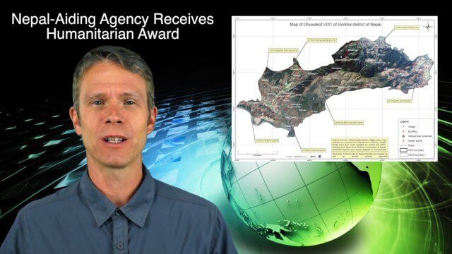
8_20 Infrastructure Broadcast (Smart Cities, Nepal Recovery and More)
0 Views0 Comments0 Likes
This Infrastructure-themed GeoSpatial Stream broadcast discusses Smart Cities initiatives and reports to help urban areas become more sustainable and livable; updates from engineers concerning Nepal's earthquake recovery; industry news from Topcon Positioning Group, Woolpert, gViz and IMAGINiT; thoughts on the growing Smart Cities industry; and more.


