
tdanielson / Added Videos
USAFA Reality Capture Showcase: Pete Kelsey, Autodesk
3.84K Views0 Comments0 Likes
V1 Media was at the U.S. Air Force Academy (USAFA) Reality Capture Showcase at the Department of Civil and Environmental Engineering, interviewing Pete Kelsey, Strategic Projects Executive, Autodesk.

4_22 GEOINT Broadcast (Keynote Highlights, Major News and Developments, and More)
3.82K Views0 Comments0 Likes
This GeoSpatial Stream broadcast from the GEOINT Symposium in Tampa, Fla., recaps the major highlights and news from the event, including keynote addresses from James R. Clapper, Director of National Intelligence; Letitia A. Long, Director, National Geospatial-Intelligence Agency; and Lt. Gen. Michael T. Flynn, U.S. Army, Director of the Defense Intelligence Agency. The broadcast also covers major news announcements from the U.S. Geospatial Intelligence Foundation, Boeing, Surrey Satellite Technology U.S., Airbus Defense & Space, and more.

8_20 Infrastructure Broadcast (Smart Cities, Nepal Recovery and More)
3.81K Views0 Comments0 Likes
This Infrastructure-themed GeoSpatial Stream broadcast discusses Smart Cities initiatives and reports to help urban areas become more sustainable and livable; updates from engineers concerning Nepal's earthquake recovery; industry news from Topcon Positioning Group, Woolpert, gViz and IMAGINiT; thoughts on the growing Smart Cities industry; and more.

NASA’s Top 17 Earth From Space Images of 2017
3.81K Views0 Comments0 Likes
The people at the Earth Science and Remote Sensing Unit at NASA’s Johnson Space Center in Houston had the enviable job of going through this year’s crop to pick their top 17 photos of Earth for 2017—here’s what they chose!
Linking Project Delivery with Asset Management
3.80K Views0 Comments0 Likes
The V1 Video team interviewed Bill Pratt at the 2015 Bentley Year in Infrastructure Conference in London in early November. Pratt is principal engineer, AEC Applications, Connecticut DOT, and he discussed how he and his fellow engineers are looking to improve project delivery, asset management and project tracking by using new technology.
IMAGINiT Talks BIM and Lifecycle Management
3.80K Views0 Comments0 Likes
The V1 Video team was at Autodesk University 2015 in Las Vegas and interviewed Carl Storms, Senior Application Expert, and Matt Mason, Director of Software Development, both with IMAGINiT Technologies. They discussed BIM use throughout a project's lifecycle, the company's Clarity owner data portal and its benefits to users, and the latest updates for its Scan to BIM product for use with Revit.
Matt Zbysenski Interview (IES Engineering)
3.80K Views0 Comments0 Likes
Matt Ball interviews Matt Zbysenski, Piping Designer, IES Engineering, at SPAR International in Colorado Springs, Colo. They discuss LiDAR in the construction workflow, safety mitigation, cost/time savings, pre-fabricated construction, and oil & gas uses.
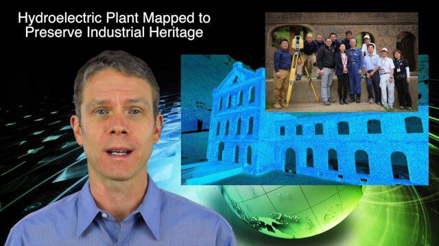
5_14 Infrastructure Broadcast (Nepal Update, 3-D Mapping and More)
3.79K Views0 Comments0 Likes
This Infrastructure-based GeoSpatial Stream broadcast provides an update from the latest earthquake in Nepal as well as related maps from Caltech and JPL concerning the area's geology and effects; 3-D mapping of an industrial heritage site in Japan; industry news from Trimble, Leica Geosystems and IMAGINiT; Nepal relief work geared toward rebuilding the area; and more.

Data Enablement for Better Decision Making
3.79K Views0 Comments0 Likes
The V1 Video team interviewed Don Murray, Co-Founder and President of Safe Software, at the 2015 Esri User Conference in San Diego. We spoke about transforming geospatial data into different formats such as Minecraft for greater community engagement as well as combining buildings and GIS data for greater context. Safe Software is all about data, allowing for analysis, processing, storing and integrating data for better decision making.

5_15 Asia-Pacific Broadcast (Sri Lanka Transit GIS, China World Map and More)
3.79K Views0 Comments0 Likes
This Asia-Pacific-focused GeoSpatial Stream broadcast discusses a train accident in Sri Lanka and how a new GIS may prevent future collisions; India's groundwater mapping; China's World Map online; Australia's 2014 Esri Young Scholars Award winner; industry headlines from Trimble, Tencent and NavInfo, and NZ Aerial Mapping; the World Under Water Web site; and more.


