
tdanielson / Added Videos
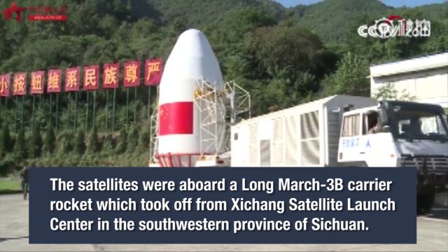
China Launches Two BeiDou-3 Navigation Satellites
3.25K Views0 Comments0 Likes
China launched two BeiDou-3 satellites into space via a single carrier rocket to support its global navigation and positioning network at 7:45 p.m. on Nov. 5, 2017.

Circle of Blue: Where Water Speaks
879 Views0 Comments0 Likes
In a disruptive era, when risks are becoming realities, Circle of Blue reports from the front lines.
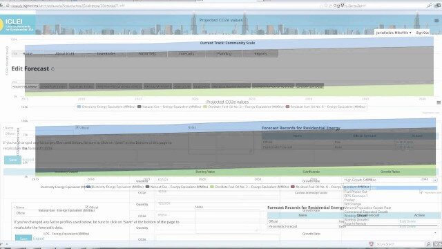
ClearPath Emissions-Management Software
2.33K Views0 Comments0 Likes
ClearPath is the next generation of ICLEI's online software suite for local governments managing energy, resources, and GHG emissions. ClearPath offers a powerful and integrated cloud-based platform that allows you to visualize your current and future emissions, and easily carry out sophisticated analysis to determine the right mix of policies to meet your emissions reduction goals.
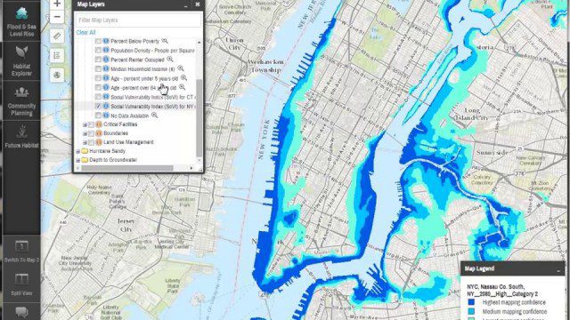
Coastal Resilience 2.0
2.12K Views0 Comments0 Likes
Providing tools to reduce ecological and socioeconomic risks of coastal hazards, the app enables users to assess such risks, including those to current and future storms, as well as sea level rise scenarios; identify solutions to reduce risks across socio-ecological systems; take action to help communities develop nature-based solutions; and measure effectiveness to ensure efforts are successful.
Commercial Drones Give A Bird’s Eye View for Inspections
1.28K Views0 Comments0 Likes
Commercial drones from Aerialtronics take flight with Watson IoT and cognitive visual recognition capabilities. Together, IBM Watson IoT and Aerialtronics can help companies open up expansive possibilities to gain insight in places not easily accessible to humans from monitoring city traffic patterns to inspecting wind turbines, oil rigs and cell tower optimization.

Commercial UAV Expo Video
2.23K Views0 Comments0 Likes
This video promotes the upcoming Commercial UAV Expo being held in Las Vegas in October 2015.
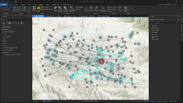
Community Contact Tracing Adds Power of Place to Contact Tracing for COVID-19
892 Views0 Comments0 Likes
By expanding the person-to-person approach, inherent in traditional contact tracing, to include person-to-person-to-place, public health analysts will be able to perform location analytics to illuminate the places where viral spread is happening outside of direct and prolonged contact between two individuals.
Community Resilience Inference Measurement
2.27K Views0 Comments0 Likes
Measuring resilience to climate-related hazards at the county level for the United States, the app allows users to directly calculate the resilience index of places they choose and view the weights of the socioeconomic factors contributing to those scores. The app also provides factors that increase or decrease resilience.
CommunityViz Web App
3.08K Views0 Comments0 Likes
Providing users with the ability to open new opportunities for education, citizen engagement, and policy change, the app enables users to quickly share their analysis results—such as energy and greenhouse gas generation and possible energy futures—with their ArcGIS Online organization, select groups, or the general public.

Conference Recap from Las Vegas (Autodesk University, Breaking News, Quadrocopters and other Innovations)
3.92K Views0 Comments0 Likes
This video was recorded in Las Vegas during the Autodesk University 2013 Conference. Topics include an extensive recap of conference events, keynotes, themes and news; the latest innovations such as quadrocopters and contour crafting; and more.


