
tdanielson / Added Videos
Fusing Data through Automation to Provide Insight
2.08K Views0 Comments0 Likes
The V1 Video team interviewed Keith Johnson, technical director for Analysis & Mission Solutions at Lockheed Martin, at the GEOINT Symposium in Washington, D.C. We spoke about making sense of imagery; wide-area full-motion video; and textual, social, civil, signals and cyber inputs for decision makers. Lockheed Martin is focused on automation to deliver the right type of data to the analyst as well as providing next-generation sensors with on-board processing that complement other expanding sensors.

Location Tracking and Advertising
1.79K Views0 Comments0 Likes
A video from The Economist describes how location technology is used to track online viewers.
Automating UAS Data Processing to Understand Change
2.33K Views0 Comments0 Likes
The V1 Video team spoke to Kevin Jones, the director of marketing for PCI Geomatics, about the company’s software to extract information from imagery. The commercial UAS market is a promising input to their image-processing tools, particularly with their automated information-extraction tools, to detect changes.

4_14 Infrastructure Broadcast (Transportation Asset Management, Water Infrastructure Needs, and More)
3.51K Views0 Comments0 Likes
This infrastructure-focused GeoSpatial Stream broadcast discusses Transportation Asset Management; a report on water infrastructure; designs to protect against hurricanes; public-transit ridership; historical map archives; private infrastructure funding; news from Bluesky and Bentley Systems; rainwater-capturing infrastructure in Rotterdam, The Netherlands; and more.
Trimble Announces Partnership with DotProduct
2.56K Views0 Comments0 Likes
Bryan Williams, Segment Manager, GCCM, Trimble Navigation, joined Tom Greaves, Chief Marketing Officer, DotProduct, to discuss a recent partnership between the two companies. In an interview with V1 Media's Todd Danielson at SPAR International, which was held March 30-April 2, 2015, in Houston, Texas, they discussed DotProduct and its products as well as how they fit into Trimble's plans. Williams also discusses vertical construction and additional new Trimble technologies.
Pushing Geospatial Content to the Edge of the Enterprise
2.28K Views0 Comments0 Likes
The V1 Video team interviewed Scott Lee, director of Federal Programs at TerraGo Technologies, at the GEOINT Symposium in Washington, D.C. We spoke about how GeoPDF products are democratizing access to geospatial data, with extensive use of the tools in the defense and intelligence communities. The company is extending access via mobile devices and empowering the consumer to mark observations that then improve the quality and accuracy of geospatial information.
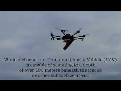
Drone with Ground Penetrating Radar (GPR)
1.67K Views0 Comments0 Likes
GPR Drone technology can be used in areas where deep ground penetration is required but high resolution is not very important.

Doug Smith Interview (Avenza Systems)
3.07K Views0 Comments0 Likes
Todd Danielson interviews Doug Smith, Director, Sales & Marketing, Avenza Systems, at the GEOINT Symposium in Tampa, Florida. They discuss Avenza's key products, including MAPublisher, Geographic Imager and its new PDF Maps app. All the products work with Adobe products for increased design functionality while maintaing location integrity.
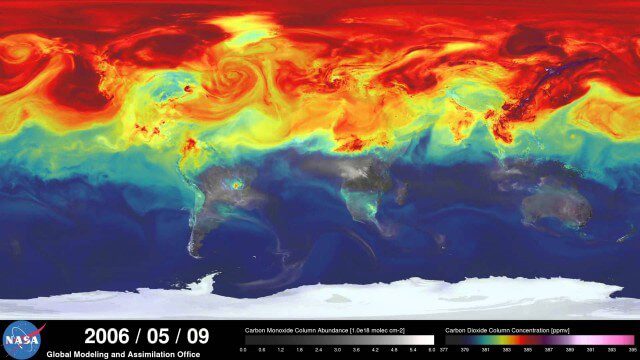
A Year in the Life of Earth’s CO2
2.02K Views0 Comments0 Likes
An ultra-high-resolution NASA computer model has given scientists a stunning new look at how carbon dioxide in the atmosphere travels around the globe.
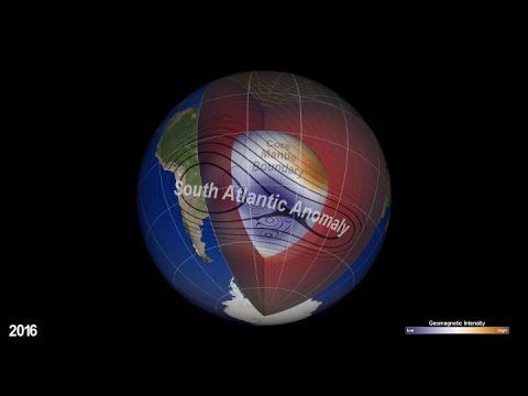
NASA Explores Earth’s Magnetic ‘Dent’
1.26K Views0 Comments0 Likes
Earth’s magnetic field acts like a protective shield around the planet, repelling and trapping charged particles from the Sun. But over South America and the southern Atlantic Ocean, an unusually weak spot in the field – called the South Atlantic Anomaly, or SAA – allows these particles to dip closer to the surface than normal.


