
Monthly Archives: May 2015
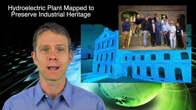
5_14 Infrastructure Broadcast (Nepal Update, 3-D Mapping and More)
0 Views0 Comments0 Likes
This Infrastructure-based GeoSpatial Stream broadcast provides an update from the latest earthquake in Nepal as well as related maps from Caltech and JPL concerning the area's geology and effects; 3-D mapping of an industrial heritage site in Japan; industry news from Trimble, Leica Geosystems and IMAGINiT; Nepal relief work geared toward rebuilding the area; and more.
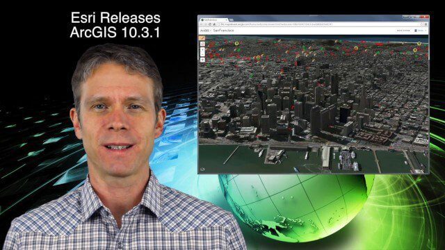
5_21 Climate Broadcast (Antarctic Ice Shelf, ArcGIS Release and More)
0 Views0 Comments0 Likes
This GeoSpatial Stream broadcast discusses a NASA study on the shrinking Antarctica Larsen B Ice Shelf; Esri's new release of ArcGIS and its improvements and updates; industry news from Blue Marble Geographics, Boundless and BlackBridge; Nepal relief work geared toward rebuilding the area; Nepal earthquake data from RADARSAT-2; and more.

5_28 Asia-Pacific Broadcast (Dinosaurs, Chinese LiDAR and More)
0 Views0 Comments0 Likes
This Asia-Pacific GeoSpatial Stream broadcast discusses project in Australia to digitally document dinosaur tracks via imaging technology; the Indian Seismic and GNSS Network, which passed the "test" of the Nepal earthquake; industry news from AAM Sky Geospatial Solutions and Takor Group; an interview clip from the Riegl LiDAR 2015 User Conference in China; a preview of the HxGN Live conference in Las Vegas; and more.

After Quake, Engineer in Khatmandu Describes What Fell Down, or Didn’t, and Why
0 Views0 Comments0 Likes
Kit Miyamoto, a structural engineer fresh from five years rebuilding Haiti, spoke with Andy Revkin of The New York Times Dot Earth blog after a day inspecting Kathmandu damage zones.
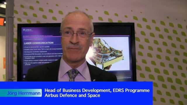
Airbus Defence and Space Brings Laser Communications to Earth Observation
0 Views0 Comments0 Likes
Earth Imaging Journal spoke with Jörg Herrmann, head of business development for the EDRS SpaceDataHighway Programme at Airbus Defence and Space, at the recent International Space Symposium. This laser-based data-relay system provides high-speed, near-real-time data transfer for Low Earth Orbit (LEO) satellites and airborne (unmanned/manned) platforms (UAS).

Airbus Defence and Space Launches WorldDEM DTM
0 Views0 Comments0 Likes
Airbus Defence and Space released its global elevation model that was captured by the twin TerraSAR-X and TanDEM-X radar satellites in 2014 and now is producing Digital Terrain Models based on this dataset. The 12-meter-resolution pole-to-pole elevation data are a major improvement upon the commonly used 30-meter USGS SRTM data. Earth Imaging Journal spoke with Gertrud Riegler, WorldDEM Product Manager, Airbus Defence and Space, at the International Space Symposium about this new dataset and its many uses.
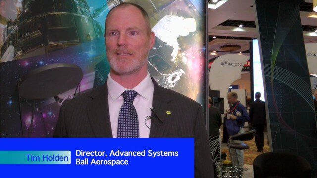
Ball Aerospace Delivers Science-Driven Sensors
0 Views0 Comments0 Likes
Ball Aerospace is a unique entity that delivers imaging instruments as well as full satellites, bringing scientists and engineers together to optimize sensor and spacecraft design. Earth Imaging Journal spoke with Tim Holden, director of advanced systems at Ball Aerospace, about sensor development, the commercialization of space and opportunities in remote sensing with increased temporal revisits.
Earth Observation Industry Alliance Looks Forward to Further Proliferation
0 Views0 Comments0 Likes
The Earth Observation Industry Alliance (EOIA) was at the International Space Symposium talking to commercial space companies about the future of Earth observation. Earth Imaging Journal spoke with Dennis Jones, chairman and president of EOIA, about the outlook for Earth observation. The goals are to promote favorable policy, a corresponding regulatory environment that's less restricting and more supportive of new companies, and a larger government budget to support observation missions.
Environmental Applications Hold Promise for Ball Aerospace
0 Views0 Comments0 Likes
Ball Aerospace has been involved with the commercial and government sides of Earth-observation satellites for some time, including instrument and satellite construction for DigitalGlobe as well as the primary imager for the Landsat 8 satellite. Earth Imaging Journal spoke with Cory Springer, director of weather and environment at Ball Aerospace, about the prospects for environmental monitoring, the need to continue the data record for the Landsat program, the CAVIS instrument on DigitalGlobe’s WorldView-3 satellite that removes the impact of weather on the image, and the motivating role of the International Space Symposium.

Exelis Aims at Small Satellite Sensor Development
0 Views0 Comments0 Likes
Earth Imaging Journal spoke with Craig Oswald, account manager for remote-sensing commercial markets at Exelis. We spoke about the smallsat market as well as maintaining high imagery quality while riding the faster, better, cheaper wave as Earth-observation satellites continue to proliferate.


