
Tag: Todd Danielson

Esri’s Director of Solutions Discusses Apps, Simplicity and Passion
0 Views0 Comments0 Likes
Todd Danielson interviews Damian Spangrud, Director of Solutions, Esri, at the 2014 Esri User Conference in San Diego. They discuss what it's like working at Esri, the tools needed to create a public-facing GIS app and "never underestimating how simple things need to be."

Topcon Products Enable Mapping from Ground, Air and Vehicles
0 Views0 Comments0 Likes
Todd Danielson interviews Barbara McInerney, Product Marketing Manager, Topcon GeoPositioning Solutions Group, at the 2014 Esri User Conference in San Diego. They discuss Topcon's GIS and mapping solutions in three main areas: from the ground, from the air and in a vehicle.

7_23 Esri UC Broadcast (Video Recap, Exhibitor News and More)
0 Views0 Comments0 Likes
This GeoSpatial Stream broadcast covers news and events from the recent Esri User Conference in San Diego, including a video recap of speakers and topics; news from Esri on the Special Achievement in GIS Awards, its Tapestry Segmentation system and a partnership with European Schoolnet; exhibitor news from Topcon Positioning Group, Airbus Defense and Space, LizardTech and Scene Sharp; a clip from an interview with Jack Dangermond, Esri's president and founder; and more.

Jack Dangermond Implores GIS Community to Get Involved to Make a Difference (4 of 4)
0 Views0 Comments0 Likes
In the final of four installments, Todd Danielson interviews Jack Dangermond, President and Founder, Esri, at the 2014 Esri User Conference in San Diego. Jack talks about his passion to solve problems, sometimes at a global scale, and enabling the next generation to help tackle the world's problems. He also encourages the GIS community to "move out and play at 100 percent."

Jack Dangermond Addresses Climate Change and the Importance of GeoDesign (3 of 4)
0 Views0 Comments0 Likes
In the third of four installments, Todd Danielson interviews Jack Dangermond, President and Founder, Esri, at the 2014 Esri User Conference in San Diego. Jack talks about the Climate Resilience App Challenge, meeting the president and working on climate issues, and the importance of GeoDesign and its growing acceptance and use.

Jack Dangermond Discusses Large Enterprise Adoption of GIS and the Role of Apps (2 of 4)
0 Views0 Comments0 Likes
In the second of four installments, Todd Danielson interviews Jack Dangermond, President and Founder, Esri, at the 2014 Esri User Conference in San Diego. Jack notes how large enterprises are increasingly using GIS, such as Starbucks, Walgreens and the Port of Rotterdam, among others. He also discusses the growing geographical user interface and the role of apps in the marketplace.

GeoSpatial Stream Adds Facebook Page
0 Views0 Comments0 Likes
GeoSpatial Stream introduced a new Facebook page at https://www.facebook.com/geospatialstream.

Valarm Interview at GeoDesign Summit
0 Views0 Comments0 Likes
Todd Danielson interviews a team from Valarm, including Lorenzo Gonzalez, CEO and Software Architect, and Edward Pultar, President and Spatial Scientist. They discuss the company's vision, its clients and how its software assimilates sensor information.
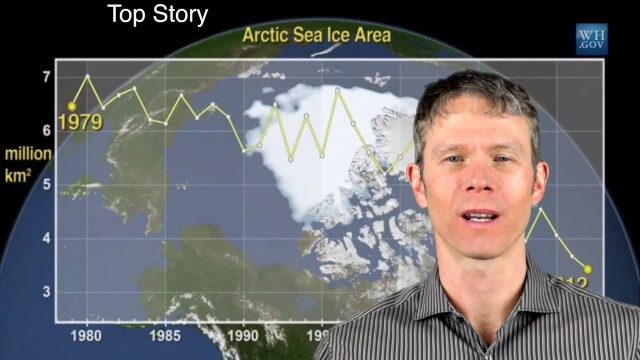
1_28 Climate Change Broadcast (Polar Vortex, China’s Pollution Plumes, Broadband Mapping and More)
0 Views0 Comments0 Likes
This GeoSpatial Stream broadcast examines the latest effects of Climate Change on the Polar Vortex; China's pollution plumes monitored from space; Kids Making Sense; broadband mapping; the latest announcements from Boundless, Cityworks, Fugro Pelagos and Blue Marble Geographics; and more.
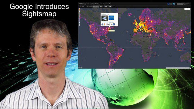
1_23 Commercial Satellite Broadcast (Google Sightsmap, Road Safety Map, Rhino Poaching and More)
0 Views0 Comments0 Likes
This GeoSpatial Stream broadcast investigates the commercial satellite imagery market; Google's Sightsmap; the WHO Road Safety map; Rhino poaching; business dealings of GRAPHISOFT, Trimble, Sputnik Enterprises; and more.


