
Tag: Internet
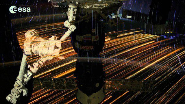
Earth Images from ESA Astronaut Alexander Gerst
0 Views0 Comments0 Likes
This timelapse video was made from images taken by ESA astronaut Alexander Gerst orbiting Earth on the International Space Station. The video is offered in Ultra High Definition, the highest available to consumers. Be sure to change the settings in YouTube if your computer or television can handle it for the full effect. The montage is made from a long sequence of still photographs taken at a resolution of 4256 x 2832 pixels at a rate of one every second. The high resolution allowed the ESA production team to create a 3840 x 2160 pixel movie, also known as Ultra HD or 4K. Playing these sequences at 25 frames per second, the film runs 25 times faster than it looks for the astronauts in space. The artistic effects of the light trails from stars and cities at night are created by superimposing the individual images and fading them out slowly. Alexander Gerst is a member of the International Space Station Expedition 40 crew. He is spending five and a half months living and working on the ISS for his Blue Dot mission.

NASA NIMBUS: Recovering the Past
0 Views0 Comments0 Likes
50 years ago, NASA launched Nimbus to study Earth from space. Now, experts at the National Snow and Ice Data Center (part of CIRES), are recovering valuable data and images from old, long-lost film, and expanding their understanding of sea ice in the Arctic and Antarctic. Learn more from CIRES on the 1-year anniversary of Nimbus' first image:

illUmiNations: Protecting our Planet
0 Views0 Comments0 Likes
United Nations General Assembly and Secretariat buildings lit up on Saturday night in a revolutionary call for climate action in connection with the Secretary-General's climate Summit. #climate2014. "illUmiNations: Protecting Our Planet" was collaboratively designed and produced for UNDPI by the Oceanic Preservation Society, Obscura Digital and Insurgent Media.

The Global Sensor Network – University of South Australia
0 Views0 Comments0 Likes
Australia has a combined land and sea territory of more than 8 million square kilometers. Yet most of this is currently out of the reach of affordable communication. Now the University of South Australia's Institute for Telecommunications Research has turned this on its head, with the development of the Global Sensor Network. The Global Sensor Network is an innovative signal processing system which provides low cost, two-way, simultaeneous satellite communications to multiple users.
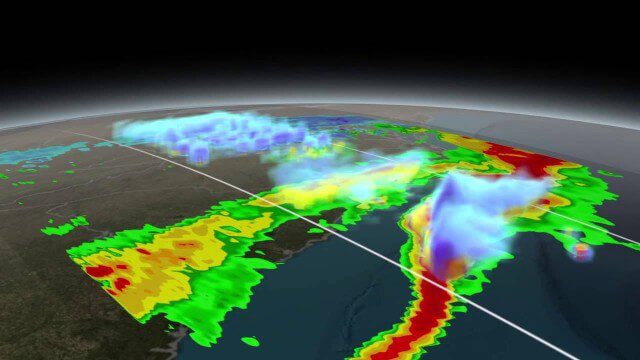
NASA Scanning a Snow Storm
0 Views0 Comments0 Likes
On March 17, 2014, the Global Precipitation Measurement (GPM) mission's Core Observatory flew over the East coast's last snow storm of the 2013-2014 winter season.
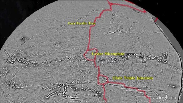
Draining the Ocean Basins with CryoSat-2
0 Views0 Comments0 Likes
This is the supplementary video for the scientific article "New global marine gravity model from CryoSat-2 and Jason-1 reveals buried tectonic structure". The full paper is available at: sciencemag.org/content/346/6205/65

FCC Geographer Byrne Receives Medal for National Broadband Map
0 Views0 Comments0 Likes
As the FCC’s geographic information officer, Michael Byrne helped create online maps and present data in ways that have made enormous amounts of information instantly available to consumers, citizen-activists and policymakers, and provided the business community with facts to make more informed commercial decisions.
Can the Next Generation of Satellites Help Predict and Battle Wildfires?
0 Views0 Comments0 Likes
Re/code visits NASA's Silicon Valley research center, where a pair of startups are working together to democratize satellite data. Aquila Space is building a fleet of satellites while its partner Astro Digital is developing software tools that allow anyone to process and analyze the data. Among other things, the information could be used to help inform policy and responses for ecological disasters, including the droughts and wildfires plaguing California.
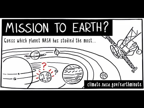
NASA’s Earth Minute: Mission to Earth?
0 Views0 Comments0 Likes
NASA doesn't just explore outer space! Since 1959, with the launch of the first weather satellite, NASA has been studying our home planet on a global scale. NASA monitors Earth's vital signs via satellites and airplanes, sends scientists to the far corners of the land and under the ocean, and develops computer models of Earth's climate processes. Why? Because Earth is the only planet that nearly eight billion people call "home sweet home."

TOPEX/JASON Sees 22-Year Sea Level Rise
0 Views0 Comments0 Likes
This visualization shows total sea level change between 1992 and 2014, based on data collected from the TOPEX/Poseidon, Jason-1, and Jason-2 satellites. Blue regions are where sea level has gone down, and orange/red regions are where sea level has gone up. Since 1992, seas around the world have risen an average of nearly 3 inches. The color range for this visualization is -7 cm to +7 cm (-2.76 inches to +2.76 inches), though measured data extends above and below 7cm(2.76 inches). This particular range was chosen to highlight variations in sea level change. Download the visualization: http://svs.gsfc.nasa.gov/cgi-bin/deta....


