


Category: Infrastructure

8_4 Infrastructure Broadcast (TIGER Grants, Transit Tech and More)
0 Views0 Comments0 Likes
This Infrastructure-themed GeoSpatial Stream broadcast discusses $500 million in grants from the USDOT's TIGER program; highlights from the latest issue of Informed Infrastructure magazine; new virtual reality technology to promote transit; industry news from Pix4D, Thinkbox Software and the Global Infrastructure Hub; a video from the Mississippi Watershed Management Organization about a stormwater filtration system recently installed near Minneapolis; and more.
3_26 Infrastructure Broadcast (Urban Sprawl, Climate Change and More)
0 Views0 Comments0 Likes
This Infrastructure-themed GeoSpatial Stream broadcast discusses a new report on the varied negative impacts of urban sprawl; an article in Informed Infrastructure about the effects of climate change on aging infrastructure; a summary of recent infrastructure spending; industry news from Esri, Topcon Positioning Group, Digi-Star, Space Foundation, Taylor Devices and Trimble; efforts from URISA's GISCorp in disaster-stricken Vanuatu; and more.
12_11 Infrastructure Broadcast (Autodesk University, Bentley Webcast and More)
0 Views0 Comments0 Likes
This GeoSpatial Stream broadcast discusses infrastructure news and videos, including highlights from Autodesk University (AU) in Las Vegas; a Bentley Systems/Informed Infrastructure Webcast on Steel Fabrication; The Nature Conservancy's Urban Water Blueprint; industry news from Topcon Positioning Group, Intergraph and Mott MacDonald; video clips from AU keynotes; and more.

12_17 Infrastructure Broadcast (Autodesk University, Sponge Parks and More)
0 Views0 Comments0 Likes
This Infrastructure-themed GeoSpatial Stream broadcast features a recap of the Autodesk University event in Las Vegas; recent coverage in Informed Infrastructure magazine about AU, Bentley Systems' Year In Infrastructure Event, and a cover story on a bridge rendering and model in Mobile, Ala.; a proposed Sponge Park near New York City to mitigate contaminated water; industry news from Terracon, Intelligent Light, Visual Technology Services, Atkins and Leica Geosystems; a Final Thought about the upcoming holidays and New Year; and more.
11_6 Trimble Dimensions Broadcast (Event Recap, Highlights and News)
0 Views2 Comments0 Likes
This GeoSpatial Stream broadcast was recorded onsite at the Trimble Dimensions 2014 Conference in Las Vegas, Nev., providing a recap of video highlights and news from the event.
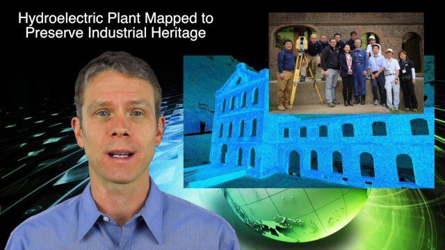
5_14 Infrastructure Broadcast (Nepal Update, 3-D Mapping and More)
0 Views0 Comments0 Likes
This Infrastructure-based GeoSpatial Stream broadcast provides an update from the latest earthquake in Nepal as well as related maps from Caltech and JPL concerning the area's geology and effects; 3-D mapping of an industrial heritage site in Japan; industry news from Trimble, Leica Geosystems and IMAGINiT; Nepal relief work geared toward rebuilding the area; and more.
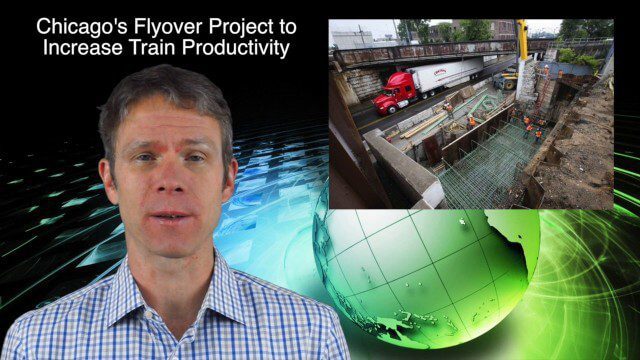
10_30 Infrastructure Broadcast (Green Buildings, Bridge Construction and More)
0 Views0 Comments0 Likes
This GeoSpatial Stream broadcast discusses infrastructure news and videos, including a report on Green Buildings; the new Englewood Flyover train project in Chicago; a smart traffic-light network; accelerated bridge construction in Rhode Island; industry news from Esri Canada, Innovyze, Maptek and Autodesk; the upcoming Trimble Dimensions conference in Las Vegas; and more.

4_2 Infrastructure Broadcast (Landsat and Flood Risk, Cloud-Based Tools, and More)
0 Views0 Comments0 Likes
This infrastructure-focused GeoSpatial Stream broadcast discusses how Landsat is helping with flood risk to infrastructure; North Carolina using cloud-based property data; a Regional Road Construction Map in Spokane; industry news from Columbia Pipeline Group, Synergis, Cityworks and Bentley Systems; surveying in the British Virgin Islands; the Technology of Walking; and more.

5_12 Infrastructure Broadcast (Earthquakes, Streetcars and More)
0 Views0 Comments0 Likes
This Infrastructure-themed GeoSpatial Stream broadcast covers the devastating earthquake in Ecuador on April 16, 2016, and relief efforts from Miyamoto International to help rebuild the city's hard-hit infrastructure; a recently opened $100-million-dollar streetcar project in Kansas City; industry news from Trimble, Bentley Systems, Transoft Solutions and Autodesk; a video interview clip about Chicago's famed 150 N. Riverside Building; and more.
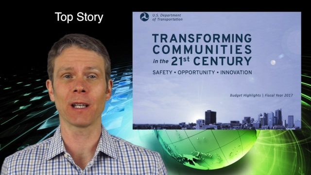
2_11 Infrastructure Broadcast (DOT Budget, Rebuilding Schools and More)
0 Views0 Comments0 Likes
This Infrastructure-themed GeoSpatial Stream broadcast discusses the FY2017 U.S. Department of Transportation budget; Los Angeles' new GeoHub; Miyamoto Relief engineering work at schools in Nepal; industry news from Autodesk, Abvent, TerraGo, Cadcorp and Topcon; two new infrastructure posting from V1 Media; and more.


