


Category: Conference Interviews
Airbus Defence and Space Brings Laser Communications to Earth Observation
0 Views0 Comments0 Likes
Earth Imaging Journal spoke with Jörg Herrmann, head of business development for the EDRS SpaceDataHighway Programme at Airbus Defence and Space, at the recent International Space Symposium. This laser-based data-relay system provides high-speed, near-real-time data transfer for Low Earth Orbit (LEO) satellites and airborne (unmanned/manned) platforms (UAS).
Ball Aerospace Delivers Science-Driven Sensors
0 Views0 Comments0 Likes
Ball Aerospace is a unique entity that delivers imaging instruments as well as full satellites, bringing scientists and engineers together to optimize sensor and spacecraft design. Earth Imaging Journal spoke with Tim Holden, director of advanced systems at Ball Aerospace, about sensor development, the commercialization of space and opportunities in remote sensing with increased temporal revisits.
Environmental Applications Hold Promise for Ball Aerospace
0 Views0 Comments0 Likes
Ball Aerospace has been involved with the commercial and government sides of Earth-observation satellites for some time, including instrument and satellite construction for DigitalGlobe as well as the primary imager for the Landsat 8 satellite. Earth Imaging Journal spoke with Cory Springer, director of weather and environment at Ball Aerospace, about the prospects for environmental monitoring, the need to continue the data record for the Landsat program, the CAVIS instrument on DigitalGlobe’s WorldView-3 satellite that removes the impact of weather on the image, and the motivating role of the International Space Symposium.

Airbus Defence and Space Launches WorldDEM DTM
0 Views0 Comments0 Likes
Airbus Defence and Space released its global elevation model that was captured by the twin TerraSAR-X and TanDEM-X radar satellites in 2014 and now is producing Digital Terrain Models based on this dataset. The 12-meter-resolution pole-to-pole elevation data are a major improvement upon the commonly used 30-meter USGS SRTM data. Earth Imaging Journal spoke with Gertrud Riegler, WorldDEM Product Manager, Airbus Defence and Space, at the International Space Symposium about this new dataset and its many uses.
Harris Tracks and Responds to Earth Observing Transformations
0 Views0 Comments0 Likes
Earth Imaging Journal spoke with Bill Gattle, vice president and general manager of national systems at Harris, with responsibility for space and intel business (commercial and government) as well as geospatial, imagery and Earth-observing technologies. We spoke about sensing, processing and providing actionable information to the marketplace. The accessibility of space, commercialization of sensors and high-powered analytics is transforming the market and expanding the applications and insights.

Exelis Aims at Small Satellite Sensor Development
0 Views0 Comments0 Likes
Earth Imaging Journal spoke with Craig Oswald, account manager for remote-sensing commercial markets at Exelis. We spoke about the smallsat market as well as maintaining high imagery quality while riding the faster, better, cheaper wave as Earth-observation satellites continue to proliferate.
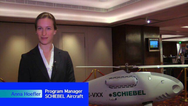
Single-Rotor Camcopter Extends Range and Flight Times
0 Views0 Comments0 Likes
Informed Infrastructure spoke with Anna Katharina Hoefler, program manager at SCHIEBEL, at the RIEGL LiDAR Conference in Hong Kong. The rugged and large-scale single-rotor CAMCOPTER has a flight time of greater than six hours and a range from 50-200 kilometers.

Processing and Visualizing Seamless Mobile LiDAR Point Clouds
0 Views0 Comments0 Likes
Informed Infrastructure spoke with Mika Salolahti, Business Development Manager at Terrasolid, about the processing and visualization of high-quality LiDAR point clouds. The visualization of tramlines in Helsinki, including overhanging wires, proves a powerful tool for asset management, maintenance and planning.

Pioneering LiDAR Adoption in China
0 Views0 Comments0 Likes
Informed Infrastructure interviewed Yanjing Liu, CEO of Five Star Electronic Technology, at the RIEGL LiDAR Conference in Guangzhou, China. Liu left his academic position at Virginia Tech and companies he founded in the United States to pioneer the use of LiDAR in China. We spoke about the hard work needed to set up this capacity as well as some landmark projects, including 3-D mapping of the Great Wall.

Promoting the Value of 3-D Data for the Nation
0 Views0 Comments0 Likes
Informed Infrastructure spoke with Jim Van Rens, CEO of RIEGL USA, at the company’s user conference in Hong Kong. Jim is actively involved in helping promote the U.S. Geological Survey’s 3D Elevation Program (3DEP) that aims to map the country in high-resolution 3-D using LiDAR and aligned technologies.


