
Monthly Archives: August 2015

LizardTech Combining LiDAR Point Cloud and Image Compression
0 Views0 Comments0 Likes
The V1 Video team interviewed Jeff Young, Manager of Regional and International Sales for LizardTech, at the 2015 Esri User Conference in San Diego. The company launched the 9.5 release of its GeoExpress software, which combines image and LiDAR compression technology. The latest tools add automation for color balancing and indexing images.

Pictometry Developing 3D Models for Infrastructure Market
0 Views0 Comments0 Likes
The V1 Video team interviewed Jim Murray, Regional VP for Infrastructure at Pictometry (an EagleView company), at the 2015 Esri User Conference in San Diego. We spoke about the unique characteristics of high-resolution oblique imagery from Pictometry and an emerging ability to create detailed 3D models with oblique imagery data draped on buildings for a photorealistic model.

RIEGL Creating 3D Data for Improved Disaster Response
0 Views0 Comments0 Likes
The V1 Video team interviewed James Van Rens, CEO of RIEGL USA, at the 2015 Esri User Conference in San Diego. We spoke at the 3D Mapping Forum, focusing on the need to map the shoreline for improved disaster response. The company also showcased its new RiCOPTER mapping drone.
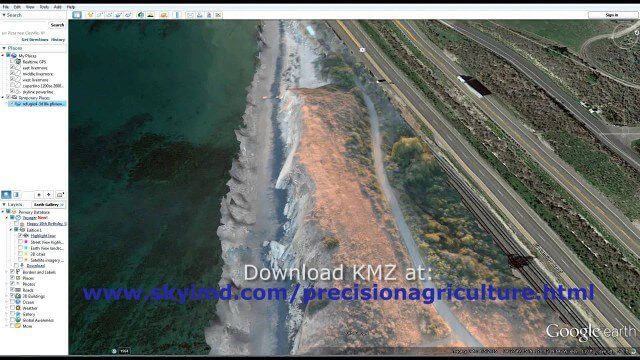
Santa Barbara Refugio Oil Spill in 3D Using Canon Camera
0 Views0 Comments0 Likes
Santa Barbara Refugio Beach Oil Spill, May 20-21, 2015. While flying precision agriculture grapes Sky Imaging Mapping Data diverted to Santa Barbara. On arrival the entire area was imaged from 12-1500 feet above the ocean. Post flight the imagery was processed into 3D models and overlaid on Google Earth for easy browsing (waves look jagged).

Trimble Discusses Mobile Device Evolution and Flexibility for Precision
0 Views0 Comments0 Likes
The V1 Video team interviewed Matt van Doorn, Product Manager in Trimble’s Geospatial Division, at the 2015 Esri User Conference in San Diego. We spoke about the rugged requirements of a professional device vs. a smartphone for field data collection. The market is good for both approaches, pairing a smartphone via a bluetooth device for high-precision collection.


