
Monthly Archives: July 2014

7_23 Esri UC Broadcast (Video Recap, Exhibitor News and More)
0 Views0 Comments0 Likes
This GeoSpatial Stream broadcast covers news and events from the recent Esri User Conference in San Diego, including a video recap of speakers and topics; news from Esri on the Special Achievement in GIS Awards, its Tapestry Segmentation system and a partnership with European Schoolnet; exhibitor news from Topcon Positioning Group, Airbus Defense and Space, LizardTech and Scene Sharp; a clip from an interview with Jack Dangermond, Esri's president and founder; and more.
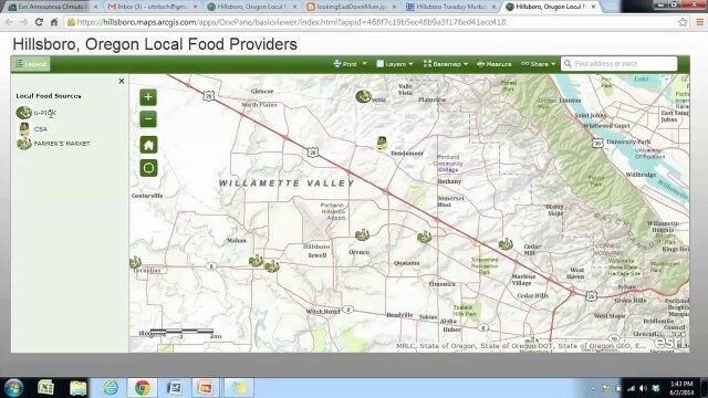
Local Food Alternatives in Washington County
0 Views0 Comments0 Likes
The app provides information on the availability of local and seasonal produce from nearby farms, markets, and vendors to empower Washington County consumers to reduce their carbon footprint and support their local community.

7_10 Remote-Sensing Broadcast (NASA, UN and More)
0 Views0 Comments0 Likes
This remote-sensing themed GeoSpatial Stream broadcast discusses NASA's recently launched Orbiting Carbon Observatory-2 satellite as well as its upcoming ISS-RapidScat instrument; The Satellite Project created at New York University; UN Peacekeeping missions using unarmed UAVs; industry news from Fugro, exactEarth, SimActive and EOMAP; the upcoming Esri User Conference; the Climate Resilience App Challenge; and more.

OCO-2: NASA’s New Carbon Counter
0 Views0 Comments0 Likes
NASA's OCO-2 mission will shed new light on understanding carbon and its role in our planet's future.

Esri App Challenge Winners Create Actionable Tools to Strengthen Resilience Efforts
0 Views0 Comments0 Likes
Esri App Challenge Winners Create Actionable Tools to Strengthen Resilience Efforts Hundreds of Apps Submitted in Response to White House Climate Data Initiative Redlands, California—July 15, 2014—Esri...

Jack Dangermond Discusses User Conference Highlights, GIS “Critical Mass” (1 of 4)
0 Views0 Comments0 Likes
In the first of four installments, Todd Danielson interviews Jack Dangermond, President and Founder, Esri, at the 2014 Esri User Conference in San Diego. Jack covers event highlights such as GIS aiding the fight against polio in Africa, new technologies introduced, and reaching a "critical mass" of development and use in the industry.

Jack Dangermond Discusses Large Enterprise Adoption of GIS and the Role of Apps (2 of 4)
0 Views0 Comments0 Likes
In the second of four installments, Todd Danielson interviews Jack Dangermond, President and Founder, Esri, at the 2014 Esri User Conference in San Diego. Jack notes how large enterprises are increasingly using GIS, such as Starbucks, Walgreens and the Port of Rotterdam, among others. He also discusses the growing geographical user interface and the role of apps in the marketplace.

Jack Dangermond Addresses Climate Change and the Importance of GeoDesign (3 of 4)
0 Views0 Comments0 Likes
In the third of four installments, Todd Danielson interviews Jack Dangermond, President and Founder, Esri, at the 2014 Esri User Conference in San Diego. Jack talks about the Climate Resilience App Challenge, meeting the president and working on climate issues, and the importance of GeoDesign and its growing acceptance and use.

Jack Dangermond Implores GIS Community to Get Involved to Make a Difference (4 of 4)
0 Views0 Comments0 Likes
In the final of four installments, Todd Danielson interviews Jack Dangermond, President and Founder, Esri, at the 2014 Esri User Conference in San Diego. Jack talks about his passion to solve problems, sometimes at a global scale, and enabling the next generation to help tackle the world's problems. He also encourages the GIS community to "move out and play at 100 percent."
Community Resilience Inference Measurement
0 Views0 Comments0 Likes
Measuring resilience to climate-related hazards at the county level for the United States, the app allows users to directly calculate the resilience index of places they choose and view the weights of the socioeconomic factors contributing to those scores. The app also provides factors that increase or decrease resilience.


