
tdanielson / Added Videos
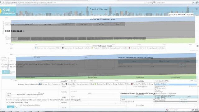
ClearPath Emissions-Management Software
2.33K Views0 Comments0 Likes
ClearPath is the next generation of ICLEI's online software suite for local governments managing energy, resources, and GHG emissions. ClearPath offers a powerful and integrated cloud-based platform that allows you to visualize your current and future emissions, and easily carry out sophisticated analysis to determine the right mix of policies to meet your emissions reduction goals.
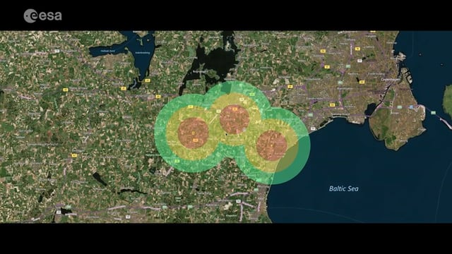
Satellite-Based Wildlife-Monitoring Tool for Airports
1.40K Views0 Comments0 Likes
Wildlife habitats close to airports pose a serious risk to safety at takeoff and landing. A new service lets airports use Earth-observation satellites to identify and manage these areas.
DigitalGlobe’s Seeing a Better World Program Focuses on Outcomes
3.32K Views0 Comments0 Likes
DigitalGlobe has expanded upon its theme of "Seeing a Better World," with a new program that focuses on themes aligned to the United Nations sustainable development objectives. Speaking with V1 Media, Taner Kodanaz, Director of DigitalGlobe's Seeing a Better World Program, describes how the company is leveraging its own imagery to provide greater context and outcome-oriented solutions around food and nutrition security, infrastructure development, sustainability, and human rights.
Hybrid VTOL Drone Eases Takeoff and Landing
2.75K Views0 Comments0 Likes
The V1 Video team interviewed Eric Westreich, who works on Business Development at Aerovel, at the 2015 Esri User Conference in San Diego. We spoke about the unique Aerovel Flexrotor hybrid-electric vertical takeoff and landing (VTOL) craft that can take off and land vertically, rotating its flight to cover more ground and takeoff from a moving platform. The Aerovel Flexrotor comes from a marine legacy, where runways aren’t possible other than on an aircraft carrier.
How to Save Time and Money When Processing Geospatial Imagery
3.70K Views0 Comments0 Likes
Are you overwhelmed by GIS data, and wish you had more time and processing power? Then check out this video from LizardTech that shows the benefits of GeoExpress, which helps geospatial professionals save time and money by compressing and manipulating satellite and aerial imagery.

RIEGL Creating 3D Data for Improved Disaster Response
2.09K Views0 Comments0 Likes
The V1 Video team interviewed James Van Rens, CEO of RIEGL USA, at the 2015 Esri User Conference in San Diego. We spoke at the 3D Mapping Forum, focusing on the need to map the shoreline for improved disaster response. The company also showcased its new RiCOPTER mapping drone.
Harris Tracks and Responds to Earth Observing Transformations
2.49K Views0 Comments0 Likes
Earth Imaging Journal spoke with Bill Gattle, vice president and general manager of national systems at Harris, with responsibility for space and intel business (commercial and government) as well as geospatial, imagery and Earth-observing technologies. We spoke about sensing, processing and providing actionable information to the marketplace. The accessibility of space, commercialization of sensors and high-powered analytics is transforming the market and expanding the applications and insights.
USAFA Reality Capture Showcase: Lt. Col. Patrick Suermann
3.17K Views0 Comments0 Likes
V1 Media was at the U.S. Air Force Academy (USAFA) Reality Capture Showcase at the Department of Civil and Environmental Engineering, interviewing Lt. Col. Patrick Suermann, Construction Division Chair.
Vector1 Media Focuses on the Future with B2B Veterans and a Multimedia Roadmap
6.32K Views0 Comments0 Likes
Vector1 Media LLC welcomes new members Kevin Carmody and Patrick Krill, makes investments in our online platforms, including an AIA accredited continuing-education site that is coming soon, and extends the reach of multimedia throughout our different channels.
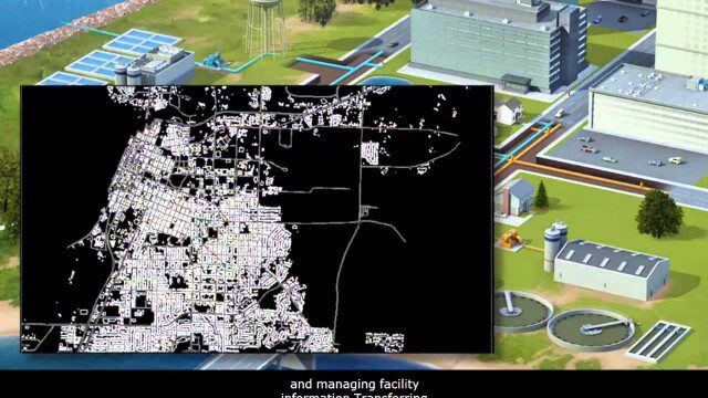
AECO Software to Manage the Urban Water Infrastructure Lifecycle
2.38K Views0 Comments0 Likes
Utilities and their consultants around the world rely on Bentley’s water solution to deliver intelligent infrastructure, ultimately providing clean water and managing sewerage and storm runoff. What architectural, engineering, construction, and operations (AECO) professionals can learn: • Maintain a centralized asset repository and manage facility information with Bentley’s integrated water and geospatial products • Model, analyze, and design water and wastewater pipe networks, using Bentley’s easy-to-use hydraulics and hydrology software • Design and build water and wastewater treatment plants in a fully-managed, collaborative team environment, using Bentley’s plant, structural, and building applications.


