
Monthly Archives: October 2014

Make It Wearable Finalists: Meet Team Nixie
2.32K Views0 Comments0 Likes
Team Nixie (http://flynixie.com) is developing the first wearable drone camera, which can be worn around your wrist. The team will be presenting their prototype for the Intel Make It Wearable Challenge Finale on November 3, 2014 in San Francisco. Learn more about Make It Wearable and follow the race to the finish line at http://makeit.intel.com. To find out more about Team Nixie, see their work at http://flynixie.com or follow them on https://www.facebook.com/flynixie.

10_30 Infrastructure Broadcast (Green Buildings, Bridge Construction and More)
4.35K Views0 Comments0 Likes
This GeoSpatial Stream broadcast discusses infrastructure news and videos, including a report on Green Buildings; the new Englewood Flyover train project in Chicago; a smart traffic-light network; accelerated bridge construction in Rhode Island; industry news from Esri Canada, Innovyze, Maptek and Autodesk; the upcoming Trimble Dimensions conference in Las Vegas; and more.
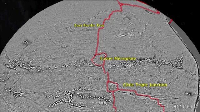
Draining the Ocean Basins with CryoSat-2
2.28K Views0 Comments0 Likes
This is the supplementary video for the scientific article "New global marine gravity model from CryoSat-2 and Jason-1 reveals buried tectonic structure". The full paper is available at: sciencemag.org/content/346/6205/65

10_2 Climate Change Broadcast (UN Climate Summit, Tsunami Evacuation Maps and More)
5.06K Views0 Comments0 Likes
This GeoSpatial Stream broadcast discusses news and video from the UN Climate Summit, including President Obama announcing new geospatial tools and pledges to restore forest land; USGS developing a pedestrian tsunami-evacuation tool; industry news from exactEarth, Bentley Systems and Innovyze; a clip from the keynote address at the recent GeCo in the Rockies conference; and more.


