
Tag: USGS
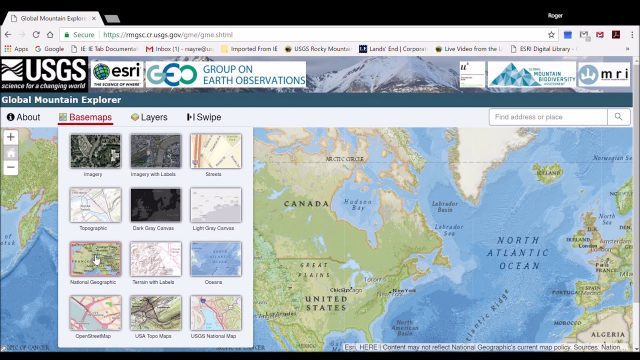
Global Mountain Explorer Video Tutorial
3.89K Views0 Comments0 Likes
This video contains a narrated introduction to the Global Mountain Explorer (GME), a web-based tool for visualizing and exploring three well known global mountain data layers.

6_9 Earth Imaging Broadcast (Satellite Success, Asteroid Mining and More)
2.47K Views0 Comments0 Likes
This Earth Imaging-themed GeoSpatial Stream broadcast discusses the recent streak of success at the European Space Agency, including its Sentinel and Galileo launches as well as a demonstration of the SpaceDataHighway; a NASA video about its North Atlantic Aerosols and Marine Ecosystems Study (NAAMES) mission; industry news from Merrick-Surdex Joint Venture, TerraGo, Earth-i, Teledyne Optech and Siteco Informatica; thoughts on asteroid mining and related benefits to Earth sensing; and more.
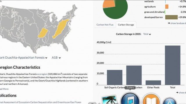
USGS LandCarbon Viewer Tutorial
1.58K Views0 Comments0 Likes
This video, narrated by USGS scientist Brad Reed, provides a brief tutorial on the use of the USGS LandCarbon Viewing tool.

3_6 ILMF Broadcast (Conference Recap, USGS News, Aerial Imagery Market and More)
3.00K Views0 Comments0 Likes
This GeoSpatial Stream broadcast discusses the recent International LiDAR Mapping Forum, important USGS news, the future of the aerial imagery market, a map contest, and more.

1_6 New Year Broadcast (2014 Predictions, National Map Corps, Gaofen-1 Satellite and More)
5.89K Views0 Comments0 Likes
This GeoSpatial Stream broadcast looks at predictions for 2014, the USGS National Map Corps, China's Gaofen-1 satellite, LiDAR "capturing" Billy the Elephant and more.


