
Monthly Archives: July 2014
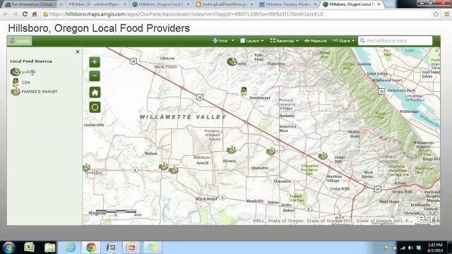
Local Food Alternatives in Washington County
2.59K Views0 Comments0 Likes
The app provides information on the availability of local and seasonal produce from nearby farms, markets, and vendors to empower Washington County consumers to reduce their carbon footprint and support their local community.

Jack Dangermond Implores GIS Community to Get Involved to Make a Difference (4 of 4)
16.75K Views0 Comments0 Likes
In the final of four installments, Todd Danielson interviews Jack Dangermond, President and Founder, Esri, at the 2014 Esri User Conference in San Diego. Jack talks about his passion to solve problems, sometimes at a global scale, and enabling the next generation to help tackle the world's problems. He also encourages the GIS community to "move out and play at 100 percent."

Jack Dangermond Discusses User Conference Highlights, GIS “Critical Mass” (1 of 4)
11.26K Views0 Comments0 Likes
In the first of four installments, Todd Danielson interviews Jack Dangermond, President and Founder, Esri, at the 2014 Esri User Conference in San Diego. Jack covers event highlights such as GIS aiding the fight against polio in Africa, new technologies introduced, and reaching a "critical mass" of development and use in the industry.

Jack Dangermond Discusses Large Enterprise Adoption of GIS and the Role of Apps (2 of 4)
13.83K Views0 Comments0 Likes
In the second of four installments, Todd Danielson interviews Jack Dangermond, President and Founder, Esri, at the 2014 Esri User Conference in San Diego. Jack notes how large enterprises are increasingly using GIS, such as Starbucks, Walgreens and the Port of Rotterdam, among others. He also discusses the growing geographical user interface and the role of apps in the marketplace.

Jack Dangermond Addresses Climate Change and the Importance of GeoDesign (3 of 4)
9.45K Views0 Comments0 Likes
In the third of four installments, Todd Danielson interviews Jack Dangermond, President and Founder, Esri, at the 2014 Esri User Conference in San Diego. Jack talks about the Climate Resilience App Challenge, meeting the president and working on climate issues, and the importance of GeoDesign and its growing acceptance and use.

IMAGINiT Helps Clients through Entire Workflow
2.33K Views0 Comments0 Likes
Todd Danielson interviews Dan Chapek, Manager, Infrastructure Solutions Team, IMAGINiT, and Jeff Bowers, Consultant, Business Solutions, IMAGINiT, at the HxGN LIVE event in Las Vegas, Nevada. They discuss how to integrate scanning data into design applications to create client deliverables, how the company partners with Leica Geosystems and Autodesk products, "field to finish" workflows, and more.

ikeGPS Demonstrates New Spike Device at Esri UC
4.03K Views0 Comments0 Likes
Brian Soliday, Senior VP of Sales, ikeGPS, demonstrates the company's new Spike measurement device at the 2014 Esri User Conference in San Diego. Featuring a laser, accelerometer and 3-D compass, combined with a camera and GPS, Spike provides and quick and easy way to "measure the world around you."

Hexagon Solutions CEO Discusses Growing Marketplace
2.69K Views0 Comments0 Likes
Todd Danielson interviews Claudio Simão, President and CEO, Hexagon Solutions, at the HxGN LIVE event in Las Vegas, Nevada. They discuss the goals of Hexagon Solutions in terms of market needs, this evolving division within Hexagon, the ripe environment for acquisitions, and more.

Google’s Project Tango – Journey
2.31K Views0 Comments0 Likes
Over the past 18 months, Project Tango has been collaborating with robotics laboratories from around the world to concentrate the past decade of research and computer vision into a new class of mobile device.
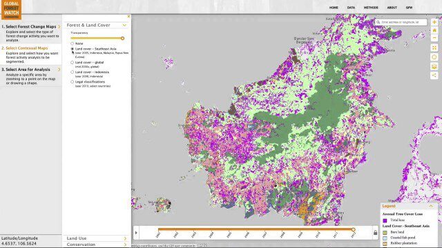
Global Forest Watch Commodities—Geospatial Tools to Help Reduce Greenhouse Gas Emissions from Land-Use Change
3.02K Views0 Comments0 Likes
This app provides three tools for businesses interested in good forest management: Suitability Mapper, which enables businesses to identify degraded areas best suited for commodity development as an alternative to clearing new forest areas; Forest Analyzer, which provides information on land cover and land use to monitor and evaluate change to forests on commodity concessions; and Roundtable on Sustainable Palm Oil (RSPO) Support tool, which users can complete for an analysis of forest change on certified areas and use the analysis for the compensation procedure required by RSPO while also enabling commodity buyers to make informed sourcing decisions.


